in Bosque County
Are you an energy company looking for mineral rights leases in the north Bosque County area? There are several land owners who would be interested in talking to you about leasing mineral rights. The total acreage of the land owners is more than 700 acres and the land is contiguous. If interested, please contact me at
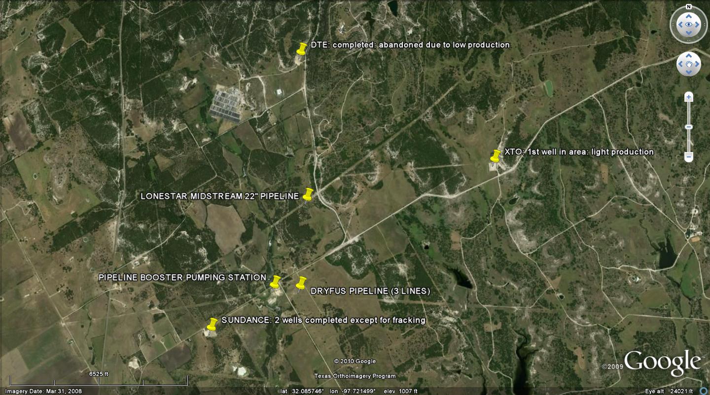
For those who are interested in the Barnet Shale natural gas exploration, the northern one third of Bosque County has seen some drilling activity into the Barnett Shale gas play over the last five years. There have been four wells drilled within in a 1.5 mile radius of my property to depths ranging from 6500 to 7000 ft , one that shows to be around 9000 ft, and one about five miles west of my house. The well to the north east of my property, drilled by DTE, produced a small amount of gas before having too much water for continued production. It has been capped and abandoned. The well to the east, drilled by XTO Energy, has produced NG at least part of the time. The XTO well appears to still be producing. Unfortunately, I do not have a clue as to what the actual production totals are. The two wells to the west, owned by Sundance Exploration, have been completed for about two years with all production equipment connected and the line from the well to the pipe line installed. These two wells have not been fracked yet. The talk on the grapevine is that the company ran into money problems, could not pay contractors, and decided to sell the wells before fracking and let the purchaser fracture and produce the wells.
There seems to be a planned effort underway to have pipelines available to carry the gas before further drilling occurs. It seems like NG pipelines are everywhere you look these days or are being brought back into good condition for transporting the NG after years of non-use. It appears the Louis Dreyfus Pipeline Company has completed refurbishing two of their three lines across the road from my land, and it appears they are working on the third line. They continue to install new control equipment on their lines and replace old pipe. Sundance has completed their wells but have never fraqued them. Quicksilver Resources drilled a well a couple of years ago about five miles west of my house on FM 203 and laid a 12 " line back to a location close to the Louis Dreyfus Energy pipelines on CR 2700 with an above ground header close to the road about one mile west of my house. They originally told land owners they were going to lay an 8" line but installed a 12" line instead. I have been told that they paid $8.00 per foot for the 8" line and then installed a 12" line instead. DTE laid a line around our county road east of my property and down the other side of the road across from my house to the Magellan pipeline booster station, and Lone Star Midstream laid a 20" high pressure gathering line across my property running from Johnson County to somewhere north east of Hico. The DTE line included three above ground headers in the line at key positions to allow hookup to more wells. We have heard talk to expect drilling activity in 3 to 5 years but that is just rumor mill stuff. The real drilling activity is still in western Johnson and eastern Somervell Counties around Hwy 67 with heavy drilling activity in the George's Creek Ranch area, and on the area of Johnson County north of the Brazos River at Brazos Point, which sits in north Bosque County, and the drilling seems to be slowly moving into Somervell County but seems to stop near the east County line in the area of the George's Creek Ranch. Maybe it will eventually get back to my area of North Bosque County. The Somervell-Bosque County line is about 6 miles to the north of my house. There was a lot of seismic graphing last year by Quicksilver around the Somervell-Bosque County lines and some of that made it down to my area of the county around CR 2700.
NEW------Added on 06/08/2010
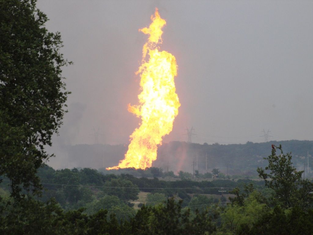
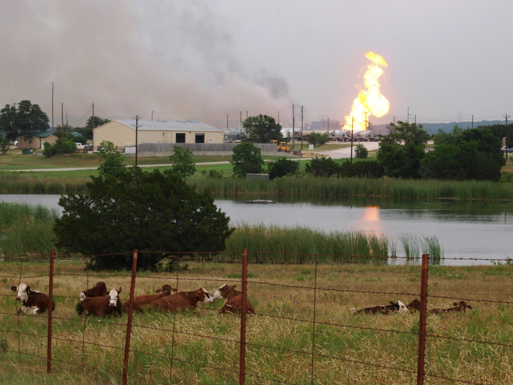
Pipeline Explosion on June 7, 2010
This occurred at apx 1430 hrs near the Johnson County/Somervell County line. I made the following two photos about one hour before the gas was shut down. A highline crew for Brazos Electric was drilling a large hole for a high line pole when it drilled into a 32" high pressure gas pipeline. The explosion killed one member of the crew, and injured 7 others.
First hand Experience with a Natural Gas Gathering Pipeline Company
We have experienced what many land owners are now experiencing and that is the fact that we do not have total control of our land in regards to natural gas and oil pipelines. Texas law stinks when it comes to protecting a land owner's property from the overbearing oil and gas pipeline companies. They will do their best to cheat the landowner out of a fair price for pipeline right of way by threatening court action if the landowner doesn't want to accept their very low price for right of way at their terms. We were lied to, threatened with condemnation, and harassed by phone in an effort to get us to settle at an amount of about 1/2 of the actual final settlement. The less they have to pay the land owner, the lower their costs and the higher their profit margin. In order to receive a fair settlement, we hired Keith Milberger of Proven Concepts Inc to represent us. The pipeline companies know the laws and how to use them to their advantage against the landowner who does not know the laws. I highly recommend Keith. I can't say this emphatically enough!!! He represents the landowner and knows the oil and gas exploration business like no other person I know. He is not cheap but he is worth every penny you will pay him! We were paid about 75% more than most of our neighbors were paid and it was all because of Keith's skills and knowledge. He took the pressure of having to deal with these people off of our backs. I did find out recently that the highest price by Lonestar Midstream for the 20" line was $16.00 per foot when it crossed a large well known ranch a few miles to the west of me. The ranch is owned by a man who has made many millions of dollars in the oil business in West Texas. Imagine that! That was exactly twice the amount that Lonestar Midstream LP paid to most land owners. Don't trust a pipeline company to tell you the truth about what they are doing! They won't! Get professional help the first time they set foot on your land, and most importantly, do not give them permission to survey your land until you seek professional help! Once you sign the right for them to survey your land, you have just taken the first torpedo to your bow and are taking on water! I know this from experience!!! Your boat is already starting to sink! They will use every trick in the book to get what they want from the land owner at the least cost to them and that means-----YOU LOOSE! If they had been co-operative and honest in dealing with me to begin with, I would not have hired outside help. The settlement was within $1.00/ft of the amount I originally told them at our first meeting that I considered to be a fair price and would accept. At that price, there would have been very few conditions and not to mention they would have not wasted four months of everyone's time and money. To their credit, I will say this about Lonestar Midstream. Once the contract was signed, they became very co-operative and were willing to work we me on several things that came up. It was dealing with them initially that was a bummer and very exasperating.
Map containing South Barnet Loop On the Proven Concepts web site. This map appears to be the accurate map of the actual route of the pipeline when completed across my land.
Map of South Barnett Loop on the LoneStar Midstream LP web site and it does not appear to be quite accurate regarding the actual route across my land! It appears to be a map of the original survey for the pipeline and not where the actual pipeline comes across my property as the route for the pipeline changed during the last month of the negotiation. I haven't had time to try to match it to accurate topographical map but it will generally give an Idea of where the pipeline runs.
Google Earth now shows an update of the area around Walnut Springs. It includes the pipelines and the wells. I have marked the pipelines and wells with labels for those interested.
Photos of the actual pipeline installation that will give you some idea as to what to expect when when a pipeline comes across your property. I will say that as much as I hated dealing with Lonestar Midstream LP and their bullying tactics the first month of our almost four month ordeal (I hired Keith Milberger one month after our first contact!), the installation crews were the best I have seen in our area. They did a double ditch installation that restored the land to almost its original condition and the dozer operators were highly skilled at what they did. The other pipelines that have been laid across the road on my neighbors property and about a mile west along the road from wells to the Louis Dreyfus pipelines left the ground with nothing but rock on the surface where some black dirt used to exist. It will take years for the land to recover to the point of supporting good grass cover or crop production. The useable black land for crops in my particular area is only a few inches thick in many areas and is very valuable to those of us who raise cattle and crops. The underlying limestone is hard to get rid of once it is brought up to the service unless care is taken by the installation crews. So to those crews who did the work on my land---a BIG THANK YOU for your diligence and care taken going through my field!
We are presently leased out to DTE (Detroit Edison Energy). When we first negotiated the lease, we were under the impression that we were leasing out to Adexco. We found out later that we are leased to DTE. I am not sure how that actually worked but I believe Adexco was hired as a front company by DTE. I don't consider that to be a very honest type of business dealing but apparently it is done on a common basis in the oil and gas business. When I found out we were actually leased to DTE, it was because they had drilled a well about one mile to the N.E. of our property and laid a pipeline from the well to the pump station across the road where there are three Dreyfus pipelines. The new installation included a huge high pressure compressor that was so noisy that it kept us awake at night. We could hear it with our windows closed and we like to sleep with the windows open! We had lived with the noise of the pipeline electric turbines for many years which amounted to only a winding up whine when they started but this new pump ran on NG fed from the well and was extremely noisy! We are about 200 yards or so up the road and could hear it inside our house with the windows closed. It was really loud at my mother's house and her rent house which was about 75 yards or so from the pumps. I caught the maintenance man at the pump one day and was able to obtain the information on who to contact regarding the noise. I talked with the General Manager who made an appointment to meet with me and the maintenance foreman and work out a way to lower the noise level. They installed noise blocking walls within a month or so and that stopped about 95% of the objectionable noise to my mother's house and about 75% of the objectionable noise to my house. At least it is at a level that is within reasonable limits. They did respond to my complaints in a timely and courteous manor which is more that one can say for a lot of producers these days! After about a year of sporatic production, DTE shut down the well, and pulled all of its equipment off the well site and the Magellan pump station property, apparently abandoning the well.
Oct, 2009: DTE did not renew any leases in our area. They sold most of their leases east of Morgan and let the leases west of Morgan expire.
The Blum Texas Website For an excellent web site with some of the best information available on the Barnett Shale in North Central Texas.
last updated on 06/08/10